


| Place of Origin: | Dongguan China |
|---|---|
| Brand Name: | OwlEye |
| Minimum Order Quantity: | negotiate |
| Price: | negotiate |
| Packaging Details: | export packing |
| Delivery Time: | negotiate |
| Payment Terms: | TT |
| Deployment Solution: | Support Both 'On Cloud Solution' (Amazon) And 'On Premises Solution' | Networking: | 4G, Ethernet |
|---|---|---|---|
| Energy Management: | Equipment Energy Acquisition And Analysis For Today, Past 7 Days, Past 30 Days | Sites Management: | Multiple Sites Management With Flexible User Defined Parameters Setting |
| Assets Create And Management: | Create And Manage Multiple Assets | Site Configuration: | Site Configuration Information Batch Copy |
| Highlight: | GIS IOT Remote Monitoring System,Ethernet IOT Remote Monitoring System,4G GIS Map Management |
||
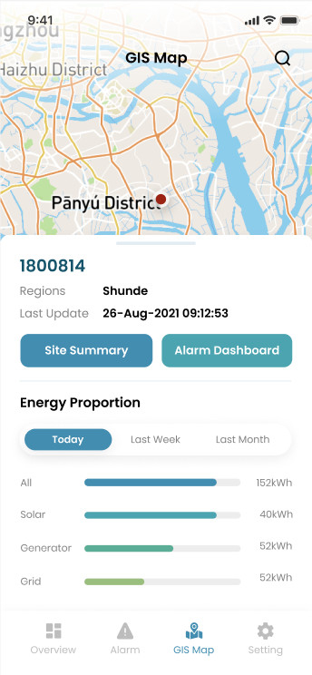
Accurate GIS Map Management IOT Remote Monitoring System
OwlEye Remote Monitoring System Functions and Features - GIS Map
|
Objective Verify GIS map functions |
|
|
Prerequisites - The OwlEye Server is running properly. |
|
| Procedure | Expected Result |
| 1.Login OwlEye Server > GIS Map | GIS Map shows up |
| 2.Put the mouse on the spot (Site) in the map. |
Display site specific information: site name, latitude and longitude, last update time and site alarm status. You can directly click site summery, alarm dashboard and Configuration Management to enter the corresponding interface. |
| 3.Click the spot (Site) | Users will be navigated to Site Summary where they can check the site overall information and open alarms |
| 4.Click show menu. | Display daily, last week, last month's dynamic time, display site number statistics and site list. |
| Remarks | |
| Test Result | |
|
Test Conclusion □ Passed □ Failed □ Exempted |
|